About All Tours From Ho Chi Minh ToursCu Chi Combo ToursFloating Market Tours1-Day ToursBoat ToursPrivate Tours Directions Hours & Fees
Find Tours 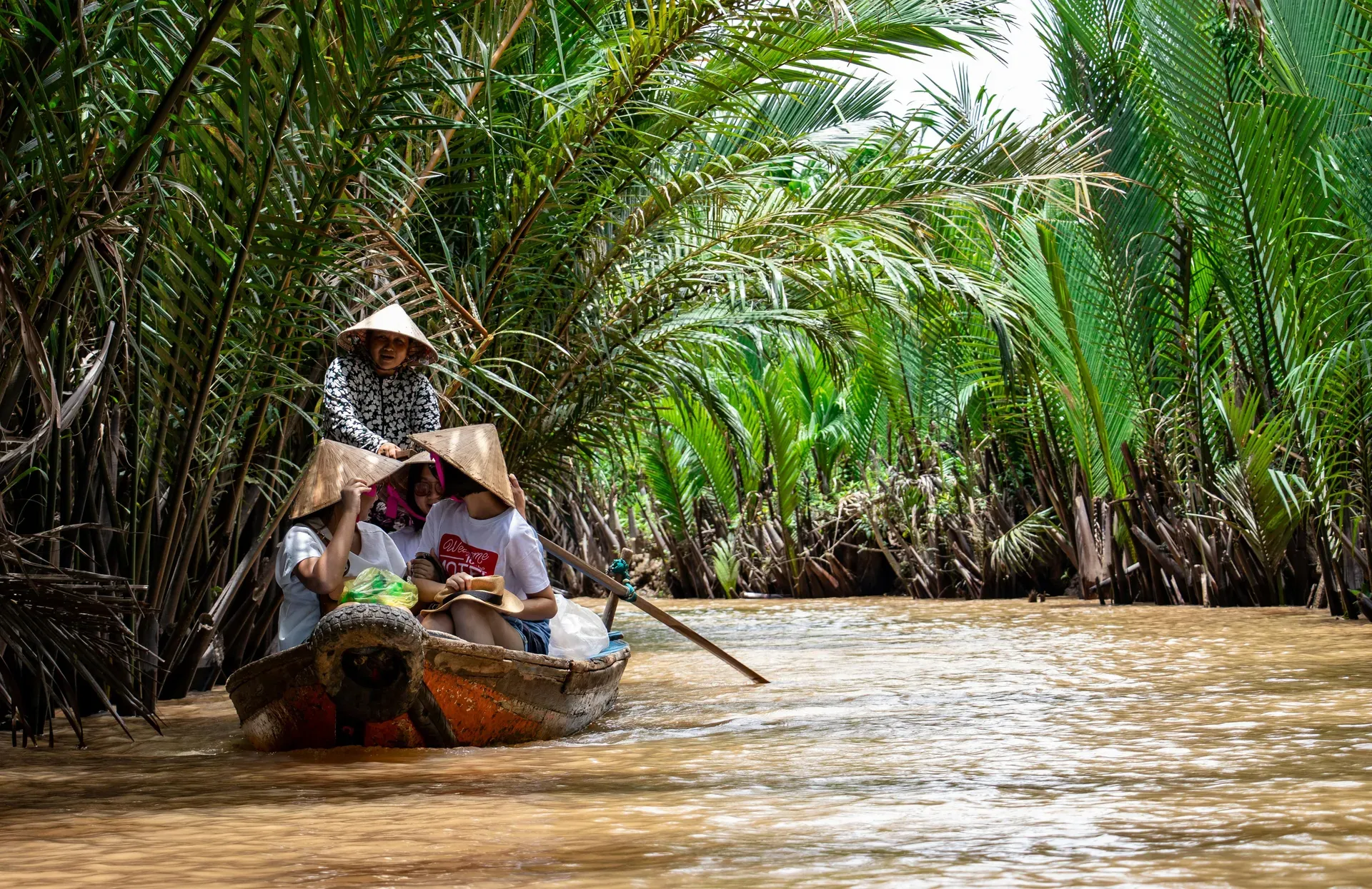
The Mekong Delta spans 40,500 square kilometers of southwestern Vietnam where the Mekong River empties into the East Sea. This massive network of distributaries produces more than half of the nation's rice and supports 17.7 million people.
Water dictates life across 40,500 square kilometers in southwestern Vietnam. The Mekong Delta forms where the Mekong River splinters into nine branches before spilling into the East Sea. Flat floodplains sit just 0.8 to 1.2 meters above sea level, creating a landscape dominated by canals, rice paddies, and islands. This massive aquatic network supports 17.7 million people and drives the national economy. Farmers here produce 54.8% of Vietnam's rice, 70% of its fruit, and 58.3% of its fishery output. The region accounts for 31% of the country's agricultural GDP and handles 95% of national rice exports.
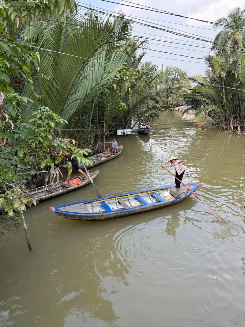
Boats outnumber cars in many rural districts. At the Cai Rang floating market, hundreds of wooden vessels gather daily between 05:00 and 09:00 AM. Sellers hang wholesale produce like pineapples, watermelons, and turnips from tall bamboo 'beo' poles, allowing buyers to spot inventory through the morning mist. The air smells of diesel exhaust, river mud, and strong robusta coffee brewing on small sampans. Vendors navigate through the chaotic traffic, passing bowls of hot noodle soup directly across the water to hungry traders. Buses depart frequently from Ho Chi Minh City's Mien Tay Bus Station, covering the 70 kilometers to My Tho in 1.5 hours for roughly 60,000 VND. Direct flights also connect to Can Tho International Airport for those skipping the overland route.
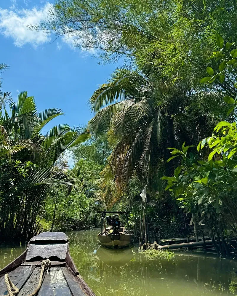
Travelers navigate a complex aquatic network. Luxury river cruises glide down the main Tiền and Hậu rivers, offering comfortable passage for elderly visitors. Narrow rowing sampans push through duckweed-covered canals in the Tra Su Cajuput Forest, requiring passengers to duck under low-hanging branches. The region demands preparation. Sudden monsoon downpours between June and August frequently cause localized flooding that halts boat travel. Mosquitoes breed rapidly in the standing water, making DEET-based repellents mandatory to prevent dengue fever. Visitors should book private boats for 300,000 to 500,000 VND to access the smaller, quieter waterways that large tour vessels cannot enter. The intense equatorial sun requires constant protection, as heatstroke poses a common risk on open-top boats.
The Funan civilization established the earliest known settlements in this region during the 4th century BC. Archeological digs at Óc Eo reveal an advanced trading network that connected the delta to India and the Roman Empire. The Khmer Empire later absorbed the territory, ruling the marshlands for centuries. They built extensive irrigation systems, though the area remained sparsely populated compared to the heartland in Cambodia.
Vietnamese migration shifted the demographic balance in the 17th century. The Nguyen Lords encouraged settlers from the north and central regions to drain the swamps and establish farming communities. This expansion pushed the borders south, transforming wild wetlands into structured agricultural zones. Chinese refugees fleeing the Qing Dynasty also arrived during this period, establishing major trading hubs like My Tho. French colonial forces seized control in the 1860s, incorporating the delta into Cochinchina. French engineers dredged massive new canals, expanding rice production for export but drastically altering the natural water flow. These deep channels allowed larger ships to penetrate the interior, fundamentally changing the local economy. The French administration constructed extensive road networks parallel to the canals, though water remained the primary mode of transit. The population surged during this era as the promise of fertile land drew thousands of landless peasants from the crowded northern deltas. The 1870-built Binh Thuy Ancient House in Can Tho survives from this era, displaying French architectural styles that later served as a filming location for the movie 'The Lover'.
Naval combat defined the delta during the Vietnam War. The U.S. Navy's Mobile Riverine Force patrolled the brown waters, engaging in fierce firefights along the narrow canals. Dense foliage like the Xeo Quyt Forest provided cover for Viet Cong jungle bases. Soldiers navigated the treacherous swamps using small, silent boats, hiding weapons in underwater caches. Bullet holes still mark some of the older concrete structures scattered along the riverbanks.
Modern development brings new challenges to the 17.7 million residents. Upstream dams in China and Laos now restrict the flow of nutrient-rich silt, threatening the agricultural output. Rising sea levels push saltwater further inland each dry season, forcing farmers to switch from rice cultivation to shrimp farming. Government regulations shape the current tourist experience. Decree 89/2023 strictly regulates exhibition licensing in the area, and tourists should avoid political discussions regarding the war. Drone operators documenting these historical sites must secure permits from the Ministry of Defence 7 to 14 days in advance, as photographing military installations carries severe penalties.
Two massive river branches, the Tiền and Hậu, anchor the delta's geography. These primary arteries split into a web of smaller distributaries that carve the 40,577.6-square-kilometer landmass into isolated islands and peninsulas. The terrain remains exceptionally flat. Average elevations hover between 0.8 and 1.2 meters above sea level, leaving the entire basin vulnerable to tidal shifts and seasonal flooding. The soil consists primarily of fine alluvial silt deposited over millennia, creating a dark, heavy mud that supports intense agricultural cultivation.
Water levels dictate the physical environment. The floating season from September to November pushes the Mekong over its banks, submerging fields under meters of brown, silt-heavy water. This annual flood deposits crucial nutrients and brings massive fish migrations. During the dry season from November to April, the water recedes, exposing steep muddy banks and requiring boats to navigate narrower channels. The land-to-water ratio fluctuates drastically between these two periods, forcing locals to build houses on tall wooden stilts or floating pontoons. Chau Doc features massive floating fish farms where wooden houses sit directly atop submerged metal cages. Farmers drop tons of feed through trapdoors in their living room floors to raise pangasius fish for global export.
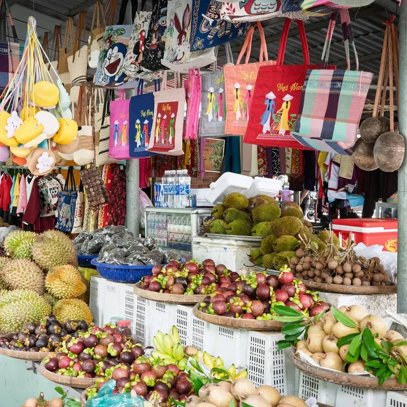
Human engineering overlays the natural geography. Thousands of kilometers of man-made canals connect the natural rivers, creating a grid system for transportation and irrigation. Orchards line the elevated banks, growing 70% of Vietnam's fruit. Visitors can sample exotic tropical fruits like durian, rambutan, and mangosteen directly from trees in Ben Tre or Vinh Long. Ben Tre features narrow canals lined with nipa palms where locals operate coconut candy workshops. The Tra Su Cajuput Forest showcases a different ecosystem, where dense canopies of cajuput trees shade water completely carpeted in bright green duckweed. This reserve acts as a critical sponge during the flood season. Visitors glide through the silent forest in traditional wooden boats, watching storks and egrets hunt in the shallow waters. The compulsory entrance ticket costs 120,000 VND, with optional motorboat and rowing boat tickets costing 70,000 VND each. The river and tap water throughout these geographical zones are unsafe for consumption, requiring locals and visitors to rely entirely on bottled water available for roughly 10,000 VND.

The Vietnamese call this region Đồng bằng Sông Cửu Long, meaning the Nine Dragon River Delta. The name reflects the nine points where the river historically met the East Sea, symbolizing power and prosperity in local mythology. Water shapes every aspect of daily life, from commerce to religion. Markets float, houses float, and even gas stations float on metal drums. The river provides transportation and food, making it the central pillar of the local identity.
Southern Vietnamese folk music, known as Don Ca Tai Tu, originated in these riverside gardens. Recognized by UNESCO, this musical tradition features stringed instruments like the dan tranh and melancholic vocals detailing the hardships and beauty of delta life. Locals perform these songs during harvest festivals, weddings, and death anniversaries. The music requires no formal stage. Musicians gather on wooden porches or the decks of boats, playing late into the humid evenings. Culinary traditions also reflect the aquatic environment. A local specialty is the Elephant Ear Fish, a large river fish fried whole and served standing upright in rice paper rolls. Street food hygiene varies across these religious and cultural festivals. Visitors should stick to busy stalls with high turnover to avoid foodborne illness.
Religious architecture blends multiple influences across the flat landscape. The Vinh Trang Pagoda in My Tho, built in the 19th century, merges Vietnamese, Chinese, and European design elements. Romanesque arches support traditional curved Asian roofs, while intricate mosaic work covers the pillars. Monks maintain strict dress codes, requiring visitors to cover their shoulders and knees before entering the prayer halls. The region supports diverse spiritual communities, including large populations of Hoa, Khmer Krom, and Cham people. Islamic mosques stand near Theravada Buddhist temples in border towns like Chau Doc, a city six hours from Ho Chi Minh City known for its floating fish farms and the sacred Sam Mountain. Entry to most temples remains free, though maintenance relies on visitor donations of 25,000 to 125,000 VND. Scams occasionally occur at ferry terminals, requiring tourists to buy tickets directly from official kiosks rather than touts offering private boat rides.
The region produces 54.8% of Vietnam's total rice output and accounts for 95% of the nation's rice exports.
The 1870-built Binh Thuy Ancient House served as a major filming location for the French movie 'The Lover'.
A local culinary specialty is the Ca Tai Tuong Chien Xu, a fish fried whole and served standing upright.
Floating market vendors advertise their goods by hanging samples on tall bamboo poles visible from a distance.
Flying a drone requires a permit from the Ministry of Defence obtained 7 to 14 days in advance.
The river and tap water are unsafe for consumption, requiring locals and visitors to rely entirely on bottled water.
The Tra Su Cajuput Forest waives its 120,000 VND entrance fee for visitors over 70 years old.
The Mekong Delta is a 40,500-square-kilometer network of distributaries in southwestern Vietnam. It forms where the Mekong River empties into the East Sea, creating a landscape of islands, canals, and agricultural plains.
The Vietnamese name, Đồng bằng Sông Cửu Long, translates to Nine Dragon River Delta. This refers to the nine branches of the Mekong River that historically flowed into the sea.
Trading peaks between 05:30 and 07:30 AM. Arriving after 09:00 AM means missing the main wholesale activity at markets like Cai Rang.
Bus rides to My Tho take about 1.5 hours, covering 70 kilometers. Reaching deeper delta cities like Can Tho or Chau Doc requires 3.5 to 6 hours by road.
From September to November, the Mekong's water levels rise and flood the fields. This annual event brings nutrient-rich silt and abundant fish to the region.
Yes, mosquitoes present a high risk due to the extensive waterways and standing water. Visitors must use DEET-based insect repellent to prevent dengue fever and malaria.
A private sampan for two to four people costs between 300,000 and 500,000 VND. These rentals typically cover a two to four-hour tour of the market and nearby canals.
Accessibility remains limited. While modern cruise vessels have ramps, village paths are often muddy, and traditional sampan boats require physical stepping-in.
Modest attire covering shoulders and knees is strictly enforced at sites like Vinh Trang Pagoda. Lightweight cotton clothing helps manage the 70-90% humidity.
Drone operation requires a permit from the Ministry of Defence. Operators must apply 7 to 14 days in advance, and photographing military installations is strictly prohibited.
Browse verified tours with free cancellation and instant confirmation.
Find Tours